
 Català
  Español

Flytec Element Track
495,00€
Big brother of the Element Speed with competition functions and navigation for free-flight, in addition to all other functions such as airspace alarm, GPS speed, intensity and wind direction or recording of the track .igc with 3D
Available on backorder. We will inform you about availability, normally 2-10 days. Refund available if delay is too big for you.
Description
Flytec Element Track
General
- Robust, shockproof ABS housing, matte black with green trim
- Tactile keypad with glove-friendly keys, high-contrast display
- Dimensions: 138 x 74 x 23 mm
- Weight: 178 g (including Batteries)
- Power supply: 2x AA batteries (Alkaline or NiMH accumulators)
- Battery life: ~35 h
- Operating temperature: 14ºF to 122ºF or -10°C to 50°C
- Languages: English, German, French Italian, Spanish
Altimeter
- Units: m / ft
- Resolution: 1 m or 1 ft
- Range: up to 40,354 ft or12,300 m
- QNH: air pressure indication in hPa or in Hg
- ALT 1: Absolute altitude
- ALT 2: Choice of absolute or relative altitude
Variometer
- Units: m/s or fpm
- Graphic indication: ±2000 ft/min. or ±10 m/s
- Graphic resolution: 40 ft/min. or 0.2 m/s
- Numeric indication: ±30,000 ft/min or ±300 m/s
- Numeric resolution; 10 ft/min or 0.1 m/s
- Averager: selectable from 1 s to 30 s
Acoustics
- Volume: 4 levels
- Vario profiles: Five predefined (weak, regular, strong, ridge soaring, balloon) – individually adjustable
- Climb tone: selectable lower threshold, frequency and cadence modulation
- Near-thermal tone: selectable lower threshold and volume adjustment
- Sink tone: selectable upper threshold and volume adjustment
- Stall alarm: selectable threshold (requires optional airspeed sensor)
- Additional vario adjustments: Base frequency, and modulation
Airspeed
- Requires optional sensor
- Units: kph, knots, mph
- Range: 0 to 74mph or 0 to 120 kph, resolution 1 mph, km/h, kt
- Calibration: ±50%
GPS
- GPS-Receiver with 48 channels
- Position determination at 1 Hz
Waypoints
- Capacity: 200 waypoints
- Entry: Store current position, manual entry, load waypoints from file
- Coordinate formats: dd.ddddd, dd’mm.mm , dd’mm’ss
- File formats: CompeGPS (.wpt) , GEO (.wpt) , Ozi Explorer (.wpt) , SeeYou (.cup), GPX (.gpx)
- Easily manage waypoint lists for each flying site
Routes
- Capacity: 1 route, with up to 50 waypoints
- Entry: Selection from waypoints list
- Race route: Start time, number of start gates, exit or enter start, start gate interval with start assistant
Navigation
- Goto: direction graphic with numeric heading and distance to waypoint
- Route: manual or automatic advancement of waypoint
- Graphic direction to next and subsequent waypoint, numeric direction and distance to next waypoint
- Speed over ground
- Current glide ratio (L/D)
- Required glide ratio (L/D) to next turnpoint
- Wind: direction graphic, and numeric direction and speed
- Last thermal: graphic and numeric direction and distance
- Units for distance: km or miles
Airspace
- Indication of direction and distance to nearest restricted airspace
- Acoustic and visual warning before entering restricted airspace
- Graphic navigation aid for quickest exit of restricted airspace
Recording
- Internal logbook: 50 flights: date, start time, duration, max altitude, max climb and sink rate
- Flight recording in IGC format
- Recording interval: 1 s to 60 s
- Record time: 100,000 hours at standard recording interval (10s)
PC Connection
- Micro-USB connector
- No connection driver/software required
- Compatible with Windows, OSX, Linux, Android (through OTG cable)
- Drag and drop file exchange (flights, waypoints, airspace)
Additional information
| Weight | 0,5 kg |
|---|---|
| Dimensions | 20 × 15 × 10 cm |
| Bluetooth | No |
| Competition routes | Yes |
| GPS | Yes |
| Live Tracking | No |
| Screen | Yes |
| Solart Panel | No |
Only logged in customers who have purchased this product may leave a review.
You may also like…
- Sale! -6.3%
 Brand: Flymaster Select options This product has multiple variants. The options may be chosen on the product page
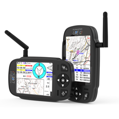
FLYMASTER NAV C
Price range: 750,00€ through 857,00€Where the DNA of the NAV SD meets the spirit of the LIVE DS, resulting in a lightweight and versatile single screen wonder. It’s the ultimate fusion, offering the best of both worlds without compromising on performance. Embrace a new era of navigation excellence with the NAV C.
- Sale! -10%
 Brand: Flymaster Select options This product has multiple variants. The options may be chosen on the product page
FLYMASTER LIVE C
Price range: 819,00€ through 926,00€Color Screen and Competition functionalities available to everyone. Experience the perfect fusion of portability, performance, simplicity and security in the world’s best livetracking. Elegant and compact like its big brother, the LIVE DS
4G multiband technology.
Connectivity with the new App “Flymaster link”.
Anti-theft system.
Extra large fonts.
Related products
 Brand: Spot Read moreMORE INFO
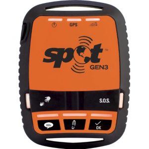
SPOT GEN3®
Original price was: 179,00€.161,10€Current price is: 161,10€.Satellite location with live tracking and coverage worldwide, allows you to be located at any time and anywhere with open sky without depending on mobile coverage and has different buttons to notify you with predefined messages assigned to each button or directly to emergency services if necessary.
* Requires annual subscription to the Basic Services Plan + Network maintenance fee from the second year:
€ 217.80 the first year and € 242 per year from the second year.
Prices August 2018 with VAT included
Check updated rate on the official Spot page.
 Brand: Stodeus Select options This product has multiple variants. The options may be chosen on the product page
UltraBip
299,99€


Reviews
There are no reviews yet.